Heart Mountain
Introduction
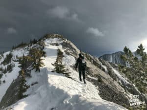
The Heart Mountain Loop is a hiking/scrambling experience allowing you to reach three different summits: Heart Mountain (2135m), Grant MacEwan Peak (2148m), and the “Large Cairn” (2120m). Located in Kananaskis Country (right at the entrance of the Rockies along the TransCanada Highway), Alberta, this panoramic ridge will offer several viewpoints of surrounding valleys and summits. Few scrambling sections are to be expected, but overall, no major difficulties if you have a bit of experience. We recommend this loop when there is little to no snow.
3D interactive map
Getting to Bow Valley Provincial Park
Parking access to Heart Mountain hike: https://goo.gl/maps/K94iq3tG7FXnWmCi7
From Calgary: 87 km – 1h driving time
Take the Trans-Canada hwy AB-1 West toward Banff until exit 105 (when you reach the Lac des Arcs). Take the bridge over the highway then a left turn toward the parking lot, 50m further.
Helpful information
To enjoy your hike, you must:
Be Equipped: Hiking boots are a necessity. A steep section of this hike (easy scramble) requires ankle protection. Hiking poles are also recommended on your way down. Bears are present in the area, therefore bear spray should be easily accessible in the case of unexpected encounters. Finally, always bring water and food in sufficient quantities.
Parking: The Heart Creek Trail Head parking lot.
Information: Access to Kananaskis Country is not free. You will need to register your vehicle(s) online on the Kananaskis park website and purchase a daily or annual pass. Note that the fees are per vehicle and not per hiker, so carpooling is an option. Be mindful of the forecast and visit the park’s website before your hike to find up-to-date information such as last seen wildlife, trail conditions, etc.
The Hike
Follow the Heart Creek trail along the highway and power lines for 750m (0.46 mi). You will reach a river bed (dry in the winter) to cross. On the other side you will find a sign on your right indicating the beginning of the Heart Mountain ascent. From this point, the hike turns into a scramble. The trail will become steep right away (gaining 700m of elevation over only 2km (1.24 mi)). After 1.5km (0.97 mi), including a 1.5 meter-high step to climb, you will arrive at the “Devil’s Staircase”, which is a short rock gully that is pretty steep and slippery. Beware of rock falls! After this section, the last 400m to reach the top is straightforward.
The Heart Mountain Loop is a hiking/scrambling experience allowing you to reach three different summits: Heart Mountain (2135m), Grant MacEwan Peak (2148m), and the “Large Cairn” (2120m).
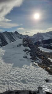
The summit of Heart Mountain (2135m) offers a 180-degree view of the Bow Valley with (unfortunately) the sight of the Lafarge cement plant right in the middle. However, you can also see the city of Canmore surrounded by famous peaks, such as Ha Ling, Grotto Moutain, and East End Of Rundle (EEOR). On the other side, you will see a ridge with a clear trail that leads to Grant McEwan Peak. Follow this trail and you will pass by a very impressive cliff.
Once at the top of Grant McEwan Peak, after 1.5km (0.94 mi) from the summit of Heart Mountain, you will have a great view of Barrier Lake, Midnight Peak, and Baldy Peak. You will be at the highest point of this hike (2148m). The loop continues on toward the third summit: “Large Cairn”, 650m further.
Heart Mountain is located in Alberta in Kananaskis Country, just at the entrance to the Rockies along the Trans-Canada Highway.
Once at Large Cairn (2120m), you will need to reach the end of the ridge called “Rock Seat” before starting the descent. Be careful, this leads to a steep and rocky section of the way down. It can be slippery and exposed in some places. You will quickly reach the forest and follow a well-defined trail for the next 2km (1.24 mi) until you get to the bottom of the mountain.
A large forestry road following the Transcanada Hwy will lead you back to your original starting point of the accent (the sign indicating Heart Mountain). To return to the parking lot, retrace your steps on the trail next to the highway and powerlines.
TO KNOW
Interest
Difficulty
Distance
Approximately 10,5 km / 6.5 miles
Duration
Around 4 or 5 hours
Elevation
2135 meters / 7005 feet
2148 meters / 7140 feet
2120 meters / 2887 feet
Elevation gain
Around 1000 meters / 3280 feet
Useful informations
See on Caltopo (detailed)
See on Google Maps (basic)
Useful links
Website: https://www.albertaparks.ca/parks/kananaskis/kananaskis-country/advisories-public-safety/trail-reports/bow-valley/grotto-creek-canyon/
Parking: https://goo.gl/maps/6jY1NJKrWjxFkr1XA
Weather forecast: https://www.mountain-forecast.com/peaks/Heart-Mountain/forecasts/2135
Download GPX: https://www.cnotremonde.com/gpx/Heart-Mountain-AB-cestnotremonde.gpx


